Collecting data with drones in the Lower Tocantins River
DEC 12 2022
In November 2022, the HARMONIZE team conducted an exploratory 2-week field campaign in the Lower Tocantins River region of the Brazilian Amazon. This mission focused on data collection via drones to characterise land use, land cover and disease habitats and improve classification algorithms of coarser resolution satellite images, as well as engagement with local communities.
The Lower Tocantins River region is located in the Northeast portion of Pará state in the Brazilian Amazon and the Microregion of Cametá. Historically, the process of occupation of this region started along the banks of the rivers, intensifying around the 17th century with the arrival of missionaries who began to structure villages and communities, encouraging extractive activities and the rearing of small animals.
The region is characterised by the presence of different environments such as upland areas, floodplains and islands, which have historically diverse forms of occupation and land use activities. For instance, in upland areas, agricultural crops or agroforestry systems predominate, such as cassava, pepper and planted and irrigated açaí palm, often intercropped with pepper or cocoa. In both islands and floodplains, flooding areas provide habitat for native açai palm, thus the production of açaí in extractive systems is the main land use activity. Currently, this region is one of the largest producing açaí both in the Amazon and globally.
Between 12th and 25th November 2022, the first Brazilian HARMONIZE fieldwork campaign was carried out in the Lower Tocantins River region as a scoping exercise. The objective of the field expedition was to collect data drone and capture information from key informants to characterise communities and their surrounding areas in terms of land use and land cover; the main modes of production associated with agricultural and agroforestry extractive activities; and the characteristics of urban infrastructure and the access of these population settlements to basic health, education, sanitation and electrical services.
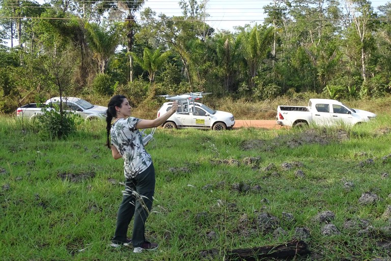
Consortium members from the Brazilian National Institute for Space Research (INPE), Fundação Oswaldo Cruz (Fiocruz) and the Barcelona Supercomputing Center (BSC) planned a 14-day itinerary for visiting local communities and peri-urban areas to define places of interest for carrying out subsequent drone flights. Travel routes between the different municipalities and communities were carried out by land and river, and included visits to islands, riverside and upland areas. The field activities included documentation through photographic records with GPS, field notes, data collection via questionnaires and consultations with residents of the visited communities such as rural producers, local representatives and institutional members.
Critically, aerial images using an unmanned aerial vehicle (UAV) were captured. These drone images will be used to support one of HARMONIZE’s key objectives - to perform longitudinal ground-truth data collection, improving land use and land cover maps with classification algorithms and downscaling of coarser-resolution environmental datasets such as satellite images, climate reanalysis and forecasts. Additionally, very high-resolution drone imagery can provide data to identify and monitor fine-scale changes in vector habitat and improve artificial intelligence (AI) classification algorithms of coarser scale satellite images over a wider geographical area.
In order to meet these objectives, this field campaign consisted of an exploratory expedition to become better acquainted with the region’s environmental conditions, local communities and the environment where the team will perform the next field campaign for data collection with the HARMONIZE consortium’s Mavic 3M drone. A key outcome from this campaign was the selection of two areas for the HARMONIZE community engagement award: one in the municipality of Cametá, the Tapera Cametá community, at risk of Chagas and malarial diseases, and another in the peri-urban region of Mocajuba, which is susceptible to dengue fever. Additionally, the team also established a flight protocol so that future fieldwork with drones could follow well-defined methodological steps safely and productively whilst optimising the collection of quality images.
Overall, during this field campaign, 46 flights were performed at a height of 120m, covering a total imaged area of 507 hectares. The total duration of mapping flights was approximately 4 hours 9 minutes with a total of 2,529 photos taken. After these images were obtained, post-processing steps were performed and mosaics of images were created to characterise land use, land cover and the presence of possible disease vector repositories in the region. This contributes to one of HARMONIZE’s main objectives to acquire high-resolution images relevant to human health.