Peru
Peru has experienced periodic outbreaks of multiple vector-borne diseases, diseases transmitted by insects or other living organisms, throughout the years. Regions such as Loreto, Piura, and Tumbes have recently reported higher incidences of dengue cases due to heavier rainfall as a consequence of Hurricane Yaku and the El Niño - Southern Oscillation phenomenon. Additionally, Peru has areas, particularly in the Amazon rainforest region, where malaria is endemic; Loreto, Ucayali, and Madre de Dios. These diseases respond to changes in climate, including changes in temperature, rainfall patterns, and extreme weather events, since these alterations create more favourable conditions for the breeding and spread of disease-carrying vectors. Poverty, inadequate access to healthcare, and substandard housing conditions, especially in rural areas in the Amazon rainforest, increase the vulnerability of communities to these diseases.
Iquitos, located in the heart of the Peruvian Amazon, is the largest city in Peru - and the world - without road access. It is the capital of the largest region of the country, Loreto, which has its own local government and is divided into provinces and districts. Loreto has an area of 368,851 km2 and 95% of the territory is covered in forest. It has a population of 1,044,884, and their main economic activities include petroleum, gas, and mineral extraction; agriculture, livestock, hunting, and forestry; and commerce. Historically, Iquitos has been one of the most affected areas by vector-borne diseases, including: dengue, malaria, and leptospirosis, among others.
In Iquitos there is a single highway recently asphalted in 2005, which connects Iquitos with Nauta, reducing the 12 hours boat trip to only a 90 minute drive. This 95km road represents an opportunity for connection and exchange for the region, but it also means that it plays a relevant role in the population’s health and its direct impact on the adjacent biodiversity. Because of this unique geography, the HARMONIZE project in Peru selected 10 communities along the highway to measure various health and climate data and to be provided to the Regional Health Directorate with the objective of providing data and tools for better decision- taking.
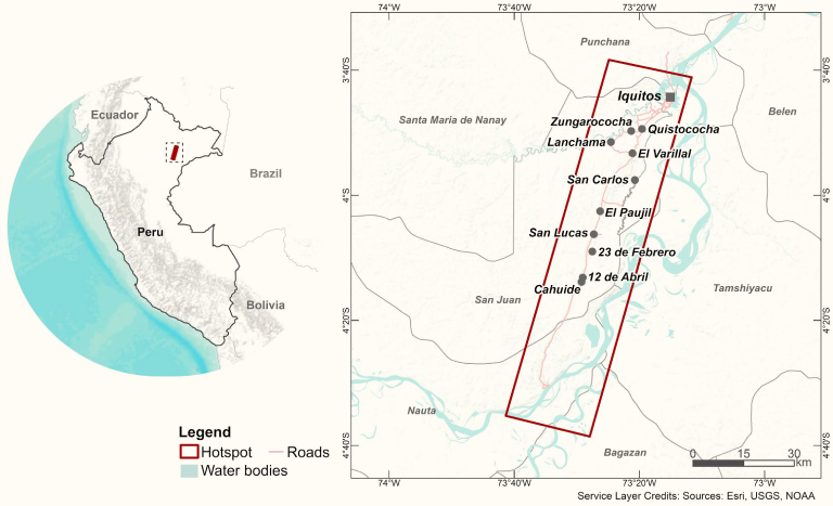
Map with the location of the hotspots in Peru
The main activities of the project in Peru, include collecting and analysing data from the 10 communities along the Iquitos-Nauta highway.
- The data collection activities include: Weather stations: installed in 5 communities which register maximum and minimum temperatures, precipitation, humidity, and atmospheric pressure, among other information collected weekly by the fieldwork team.
- Air quality sensorsinstalled in the same 5 communities which register PM2.5 concentrations. Information is collected weekly by the fieldwork team.
- Drone Surveys: every 3 months, two drones are flown over all the 10 communities. One of them with multispectral imaging, and the other with thermal imaging, in order to detect water accumulation and find possible vector breeding sites. The information collected by the drone images is reinforced or verified by point 4, described below.
- QField software. The fieldwork team physically walks through every community with devices equipped with QField software allowing the team to collect data on the go. The team seeks to visually spot possible breeding sites, especially in places that may not be registered by the drone images.
- Audiomoths: small audio recording devices that register the acoustic ecosystem (biophony, geophony, and anthropophony) of the periphery of the communities.
- In collaboration with multiple government agencies, we are also collecting historical data (2010-2023) of satellite imagery which include aerosol rates, evapotranspiration, precipitation, temperature, CO density, water vapour, and latent heat flux.
By providing the data and tools to regional and national decision-makers in climate and health, the HARMONIZE team hopes to contribute to better health outcomes in Peru.