Brazil
Brazil faces a significant burden of vector-borne diseases, including dengue fever, chikungunya, malaria, Chagas disease (also known as American trypanosomiasis) and leishmaniasis. These diseases are primarily transmitted by insects, called disease vectors, whose survival is highly dependent on climatic factors. For example, mosquitoes of the Aedes species transmit dengue, Zika, and chikungunya. Whereas Anopheles mosquitoes transmit malaria, triatomine bugs transmit Chagas ,and sand flies transmit leishmaniasis. Periodic outbreaks of these diseases occur particularly in regions with suitable environmental conditions and inadequate public health infrastructure. Rising temperatures, shifts in rainfall patterns, and extreme weather events can influence the distribution and abundance of disease vectors and modify the disease landscape. On top of this, unequal access to healthcare, sanitation, and clean water can exacerbate the spread of these diseases, particularly in low-income communities.
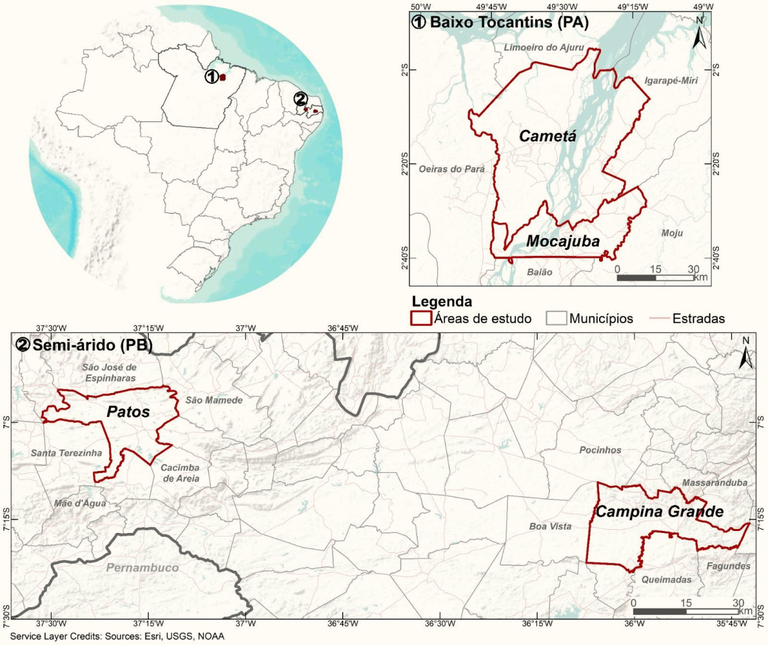
The two hotspots in Brazil - “Baixo Tocantins” (lower Tocantins river basin) in Pará state and “Sertão da Paraíba” (semi-arid region in the Paraíba state) - are areas particularly vulnerable to climate change. Baixo Tocantins is located in the humid Amazon region, which has faced increased flooding and deforestation pressure in recent years. Sertão da Paraíba is located in a semi-arid region that often faces water scarcity and periodic droughts, which increases the risk of food insecurity and infectious disease outbreaks.
Baixo Tocantins
The ‘Baixo Tocantins’ study site is located at the margin of the Tocantins River, an important tributary of the Amazon River, in the Para state, Brazil. Journey times to the core municipalities, Cametá and Mocajuba, are at least 6 hours from the state capital Belém, by road and ferry. The region comprises diverse ecologies, including dry lands, floodplain areas and islands. On the islands and in the floodplains, fishing and extracting açaí from palm trees are the main economic activities, both for domestic consumption and as a source of income. Floodplains and most islands are subject to flooding, which creates ideal conditions for the açaí palm. Community life is regulated by the environment, its climate and the Tocantins River water level. These factors affect the quality and productivity of the açaí and the fishing activities.
Malaria is an endemic disease in the region, with most infections caused by the parasite Plasmodium vivax. The majority of cases are reported among young males living in rural areas, working in activities such as family farming (subsistence crops), mining, livestock, plant extraction and fishing. The spatial distribution of malaria is associated with land use and land cover changes, such as deforestation. Other epidemiological concerns in this region are the increased incidence of cutaneous leishmaniasis and cases of Chagas disease associated with the consumption of contaminated açaí.
The dynamics of these vector-borne diseases are affected by ongoing environmental changes, including uncontrolled urbanisation, construction of roads and dams, deforestation, and the introduction of new rural technoproductive trajectories. The vulnerability of the communities can vary according to the ecology of the area they live in, such as the river margins, the islands, the flooded forest and the mainland (‘terra firme’).. To better understand how infectious disease risk varies between these areas, it is important to collect data locally at a fine spatial scale. This can serve as ground truth data, which can be used as a reference for data that does not have such a fine spatial scale.
Sertão da Paraíba
The ‘Sertão’ hotspot was chosen to represent growing cities affected by climate change. For decades, cities have acted as a refuge for populations affected by extreme climatic events such as droughts, which lead to agricultural losses and difficulties in obtaining safe and permanent access to water. Agricultural production in the area is characterised by small family-run businesses that farm beans, cotton, goats and cattle. The cities of Patos and Campina Grande in the Paraíba state are often affected by water supply shortages, during which households are forced to store and consume low-quality water. This scenario is responsible for the rapid spread of dengue and other arbovirus in the region. The concentration of cattle and domestic animals in close proximity to households can increase the risk of leishmaniasis and Chagas disease in an area.
All these health threats can be aggravated by a changing climate, through increased periods of drought and the influence of El Niño-Southern Oscillation (ENSO) in the region.Cities in Sertão da Paraíba also host regionally important universities and the health secretaries are known for their innovations and the development of low-cost technologies adapted to the local social and environmental context. However, there is a lack of technological investments and scientific support. This provides an opportunity for learning, local training and capacity building, as well as the creation and strengthening of research networks in search of adaptive solutions for areas with similar scenarios in other parts of the world.
Objectives, activities and outcomes
The main objective of the project in the two hostpots is to develop high resolution maps of vector borne disease risks for areas that present similar diseases, but very different landscapes and climates. In order to produce maps and tools to improve surveillance and response to outbreaks, data at higher spatial resolution is needed. The HARMONIZE team in Brazil will collect environmental data using drones to improve the classification of satellite images. Moreover, weather stations will be installed in two sites where there is a lack of ground data information. The output will be a detailed dataset that will inform computing tools to help stakeholders' decision-making. One annual field campaign will be carried out in each hotspot, during which workshop activities will engage local stakeholders and communities, data collection with drones will occur, and the weather stations will be monitored.
In November 2022, the HARMONIZE Team in Brazil presented the HARMONIZE Project to key Education, Health and Environment Secretariats in the Baixo Tocantins hotspots. The team explained the use of technologies and visited several localities where drones will be used throughout the project to improve landscape classification. Community members were invited to collaborate and co-develop engagement activities. Three field campaigns are planned in this area. The first campaign, scheduled for 2023, will happen over a period of 3 weeks to focus on both the engagement activities and the research activities. A workshop will be held in Mocajuba (Baixo Tocantins) to co-produce the disease risk maps and define locations to be visited by the research team to collect data using drones. In the second campaign, scheduled for 2024, engagement and research activities will be carried out in a neighbouring municipality, Cametá, where malaria is an important public health problem. In the third campaign, scheduled for 2025, the project results will be presented to the communities, including teachers and health professionals.
In Sertão da Paraíba, the project was presented in February 2023 to University, Health and Environment Secretariats in the area. Two field campaigns are planned for this hotspot: one will take place during extreme drought conditions and another during the wet season. The City suburbs in Sertão da Paraíba, were selected as representative spots for drone image collection and micro-meteorological surveys, with the support of researchers and health professionals from the region. The disease risk maps to be developed will provide support for evaluating similar areas that have not been surveyed by drones but exhibit similar epidemiological risks due to climatic and ecological conditions affected by anthropogenic influences.